
Jacksonville, Fl. —
THE TROPICS:
***** ALWAYS CHECK & RE-CHECK THE LATEST FORECAST & UPDATES! ****
Tropics threats/impacts for Jacksonville/NE Florida/SE Georgia: A bit of an uptick in the rip current risk through the weekend from low pressure to the east & northeast of Jacksonville.
The Atlantic Basin Overview:
The Atlantic hurricane season is June 1st through Nov. 30th. A couple of points right off the top:
*** the overall “environment” over the Atlantic Basin is generally conducive to the development of tropical systems through most of the rest of this month
*** the details are fuzzy at best & forecast models are generally inconsistent, especially in the longer range. It would be irresponsible for me to point to an individual model & a single run of that model & decide what’s going to happen. Be patient... don’t fall for ridiculous forecasts on social media... find a reputable & dependable source for your info... & I’ll let you know what’s going on as I determine such. Of course, one should always be prepared throughout the hurricane season.
(1) Nontropical low pressure over the Western Atlantic shed its frontal features & was upgraded to tropical storm “Dexter” Sunday night. Dexter is of no threat to any land areas as it moves steadily northeast well east of the U.S.... well north of Bermuda & then becomes extratropical - a strong ocean storm - over the North Atlantic over the next few days.
Dexter originated from low pressure that developed along a stalled front over the W. Atlantic & Southeast U.S. & Gulf Coast. The leftover front will be an area to watch for possible additional low pressure & any persistent convection. Multiple rounds of heavy rainfall for Florida, parts of the Gulf Coast & much of the Southeast U.S. can be expected to continue.

(2) Low pressure is forecast to develop not too far from Florida - to the northeast of Jacksonville- over the next couple days. This development looks like it will be a longer process vs. earlier forecasts + farther offshore. So less impact for the coastal Carolina’s & Virginia. The system may still become a tropical storm while moving east/northeast over the N. Atlantic north of Bermuda & while moving away from the U.S.
(3) The Cape Verde season is underway - which is predictable this time of year. One tropical wave in particular seems to have some long range potential but should also turn more northward with time. The GFS model has been the most bullish with this wave & sometimes has indicated impacts to the U.S. But to say it’s been inconsistent would be an understatement. How far west this wave gets & when & if it turns north will be largely determined by the strength of the sprawling Bermuda high over the Atlantic as well as the persistent summer upper level high that’s been entrenched over much of the Central & Southern U.S. There will be a split in the “heat dome” - upper level ridge - that’s been entrenched over or near the Southern & Southeast U.S. with a center more to the west & the Bermuda High over the Central Atlantic. It would appear the trough of low pressure will be maintained long enough to turn this system more to the north well east of the U.S.
A second factor in the track will be how quickly this wave develops. A stronger, earlier to deepen storm would have a tendency to end up farther north while a weaker system should go farther west thanks to steering influences from the prevailing easterlies.
(4) The European model has been hitting on a *possible* strong tropical system threatening parts of the Caribbean between about Aug. 17th & the 24th. This appears to be tied to a tropical wave that will move west from Africa by early next week. Definitely something to keep an eye on.
For what it’s worth, the Google Weather Lab AI model indicates no tropical development anywhere over the Atlantic over the next 10 days. My first impression this season so far on this model - “meh”. Time will tell.
A lot of crazy stuff being posted in the social media world as well as by those not “in the know” - stick to reliable sources(!).
7-day rainfall forecast:


‘Velocity potential anomalies’ below. shows “Rising” air (green lines) equates with an uptick in overall convection. With rising air, conditions are generally more favorable for tropical development. Where there are brown lines, the air is generally sinking & is often less conducive to tropical cyclones (though not impossible to have development). A (MJO) pulse has spread from the Pacific (where there’s been a good deal of tropical activity) to the Atlantic Basin which should lead to an overall more favorable environment across the Atlantic for at least the next few weeks.

The “Buresh Bottom Line”: Always be prepared!.....First Alert Hurricane Preparation Guide... City of Jacksonville Preparedness Guide... Georgia Hurricane Guide.
STAY INFORMED: Get the * FREE * First Alert Weather app
FREE NEWS UPDATES, ALERTS: Action News Jax app for Apple | For Android
WATCH “Preparing for the Storm”
WATCH “The Ins & Outs of Hurricane Season”
READ the First Alert Hurricane Center “Preparation Guide”
LISTEN “First Alert Weather: Preparing for the Storm”
Federal Alliance for Safe Homes (FLASH) * here *.
REMEMBER WHEN A TROPICAL STORM OR HURRICANE IS APPROACHING: Taping windows is *not* recommended & will not keep glass from breaking. Instead close curtains & blinds.
Realize the forecast cone (”cone of uncertainty”) is the average forecast error over a given time - out to 5 days - & *does not* indicate the width of the storm &/or where damage might occur.


Water vapor loop (dark blue/yellow is dry mid & upper level air):


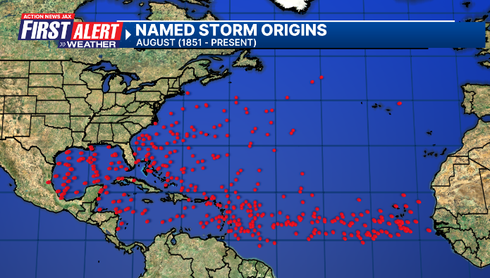
August Atlantic tropical cyclone origins:
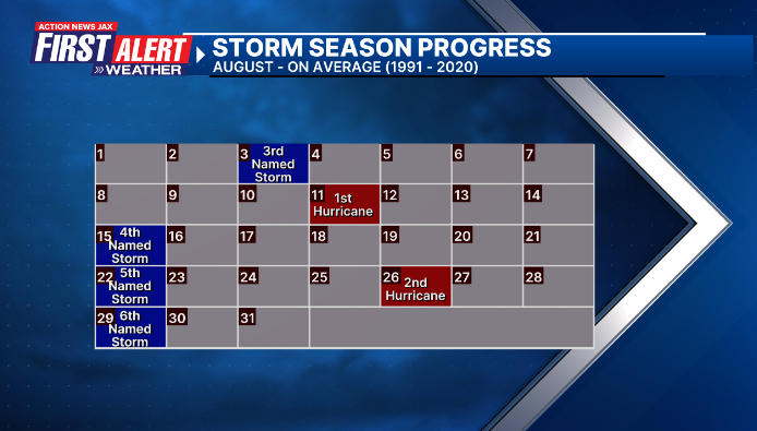
Averages below based on climatology for the Atlantic Basin for August:
Wind shear (red - strong shear; green - low shear). Shear is typically strong to start the hurricane season:


Saharan dust spreads west each year from Africa driven by the prevailing winds (from east to west over the Atlantic). Dry air = yellow/orange/red/pink. Widespread dust is indicative of dry air that *can* interfere with the development of tropical cyclones. However, sometimes “wanna’ be” waves will just wait until they get to the other side of - or away from - the dust plume then try to develop if other conditions are favorable (we saw this with Beryl & Debby last year). It’s my personal opinion that there is way too much “hoopla” about the presence of Saharan dust & how it relates to tropical cyclones. In any case, the peak of Saharan dust typically is in June & July, & we are indeed seeing a large “blobs” of Saharan dust over the Central & Eastern Atlantic that’s thinning with westward extent but enough of it to make for hazy skies across the Caribbean & - at times - across parts of Florida.

2025 names..... “Erin” is the next name on the Atlantic list (names are picked at random by the World Meteorological Organization... repeat every 6 years). Historic storms are retired [Florence & Michael in ’18... Dorian in ’19 (the last time this year’s list was used) ... Laura, Eta & Iota in ‘20 ... Ida in ‘21 ... Fiona & Ian in ‘22... no names were retired in ‘23 for the first time since 2014... & Beryl, Helene & Milton last year in 2024]). The WMO decided - beginning in 2021 - that the Greek alphabet will be no longer used & instead there will be a supplemental list of names if the first list is exhausted (has only happened three times - 2005, 2020 & 2021). The naming of tropical cyclones began on a consistent basis in 1953. More on the history of naming tropical cyclones * here *.

Hurricane season climatology:


East Atlantic:


Mid & upper level wind shear (enemy of tropical cyclones) analysis (CIMMS). The red lines indicate strong shear:

Water vapor imagery (dark blue indicates dry air):

Deep oceanic heat content over the Gulf, Caribbean & tropical Atlantic. The colors will brighten greatly as the water warms to greater depths deeper into the season. It’s worth noting that the deep oceanic heat content right now is not as high as this time last year.

Sea surface temps.:

Sea surface temp. anomalies:

SE U.S. surface map:

Surface analysis centered on the tropical Atlantic:

Surface analysis of the Gulf:

Caribbean:

Atlantic Basin wave period forecast for 24, 48, 72 & 96 hours respectively:


East & Central Pacific:
“Henriette” is crossing into the Central Pacific & is forecast to stay northeast of the Hawaiian Islands:

“Ivo” is expected to stay west of Mexico & south of the Baja of California:


Central Pacific:

Hawaii satellite imagery:


West Pacific:
Global tropical activity:


Cox Media Group


 Sign Up

